

THERE ARE TWO (2) SITES TO CHECK RED TIDE STATUS FOR CLEARWATER BEACH, INDIAN ROCKS, REDINGTON, TREASURE ISLAND AND ST. PETE BEACHES
(1) BEACH CONTIONS REPORTING SYSTEM
(FIRST SET OF LINKS BELOW)
(2) FWC
(SECOND SET OF LINKS BELOW)
CLICK ON THE LINKS BELOW FOR CURRENT RED TIDE CONDITIONS PROVIDED BY THE B.C.R.P.
The Environmental Health Research Program developed strategic and creative ways to disseminate information to the public about current environmental conditions and events, such as harmful algal blooms that affect Clearwater Beach, Indian Rocks Beach, Redington, Treasure Island and St. Pete Beaches.
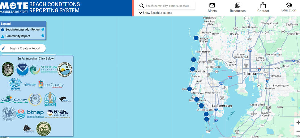
They created the Beach Conditions Reporting System (BCRS), which provides several types of information about beach locations and other recreational waterways in Florida and other coastal states.
The BCRS is a valuable tool during Florida red tide events, communicating the presence of dead fish, respiratory irritation among beachgoers, water color, and wind direction. In the absence of red tide and other events, the BCRS continues to serve as a valuable source of information for beachgoers in Clearwater Beach, Indian Rocks Beach, Redington, Treasure Island and St. Pete Beaches
FULL MAP OF THE RED TIDE INTERACTIVE REPORTING SYSTEM FROM B.C.R.P.
CURRENT RED TIDE CONDITIONS FOR CLEARWATER BEACH, INDIAN ROCKS, REDINGTON, TREASURE ISLAND AND ST. PETE BEACHES
_edited.jpg)
FWC HAS ITS OWN RED TIDE REPORTING SYSTEM AND YOU CAN CLICK ON THE LINKS BELOW FOR MORE INFO
The FWC has a map showing the most recent studies of red tide around Clearwater Beach, Indian Rocks Beach, Redington, Treasure Island and St. Pete Beaches. The map contains the last eight days of sampling and is updated each day at 5 p.m. Click on individual dots for sampling details. You can access the map HERE.
For more info about the current Red Tide status from the FWC click HERE.
FULL MAP OF THE FWC RED TIDE STATUS
_edited.jpg)
CHECK OUT THE CURRENT RED TIDE CONDITIONS FOR CLEARWATER, INDIAN ROCKS, REDINGTON, TREASURE ISLAND AND ST. PETE BEACHES
Red tide has a history of affecting the waters of CLEARWATER, INDIAN ROCKS, REDINGTON, TREASURE ISLAND AND ST. PETE BEACHES. This harmful algal bloom can cause respiratory irritation and harm marine life. It's important stay informed and take necessary precautions when visiting affected areas.
Red tide, or a harmful algal bloom, is a higher-than-normal concentration of a microscopic alga (plantlike organism). In Clearwater Beach, Indian Rocks Beach, Redington, Treasure Island and St. Pete Beaches, the species that causes most red tides is Karenia brevis, often abbreviated as K. brevis.